


Emergency Management
SKAGIT
COUNTY
2008 NATURAL HAZARDS MITIGATION PLAN
|
Please Note: The following files are in Adobe Acrobat .Pdf format. You need the Adobe Acrobat Reader browser plug-in to view and/or print Acrobat Pdf files. You can download Adobe Acrobat Reader here for free |
PRECEDING DOCUMENTS
Special Thanks & Acknowledgements
Point of Contact
Record of Changes
List of Plan Recipients
FEMA Plan Approval Letter April 2009
How To Use This Plan
Table of Contents (This page)SECTION I: THE PLANNING PROCESS (Title Page)
Introduction
Overview 2008 Plan Update
Plan Methodology
Plan Development Process
Plan Adoption
Plan MaintenanceSECTION II: MULTI-JURISDICTIONAL HAZARD IDENTIFICATION (Title Page)
Multi-Jurisdictional Community Profile
Maps:
MJ - 1 (Skagit County Map)
MJ - 2 (Skagit County Drainage Basins Map)
MJ - 3 (Skagit County Average Precipitation Map)
MJ - 4 (Skagit County Population Density by Census Block (2000) Map)
MJ - 5 (Skagit County Projected Population Growth 2000-2025 Map)
Avalanche
Drought
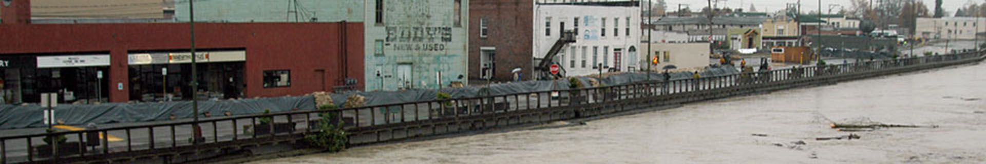
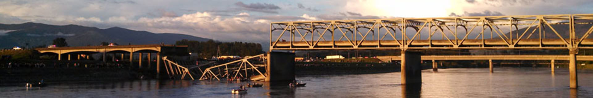
Earthquake
FireMaps:
FIRE - 1 (Skagit County Fire Districts)
FIRE - 2 (Skagit County Fire Districts and Industrial Forest Lands
FIRE - 3 (Skagit County Wildland-Urban Interface Fire Risk Assessment Compartments based on NFPA299 Risk Assessment)
FIRE - 4 (Skagit County Wildland-Urban Interface Fire Risk Assessment based on NFPA299 Risk Assessment)
FIRE - 5 (Skagit County Wildland-Urban Interface Fire Risk Assessment based on NFPA299 Risk Assessment and Fire Causes)
FIRE - 6 (Skagit County Wildland-Urban Interface Fire Risk Assessment based on NFPA299 Risk Assessment Total Acres Burned by Wildfire)Maps:
FL - 1 (FEMA FIRM for Skagit County)
FL - 2 (Skagit County FEMA Insured Parcels)
FL - 3 (Washington State NFIP Repetitive Loss Project Skagit County)
FL - 4 (Skagit County Land Use Designations and FEMA 100-year Floodplain)
FL - 5 (Skagit County Dike Districts by Assessor Tax Role)
FL - 6 (Skagit County Flood Fight Sectors)Maps:
LM - 1 (Skagit County Slope Stability (Area of WADNR Soil Survey))
LM - 2 (Skagit County Alluvial Fans)TS – 1 (Tsunami Inundation Areas in Skagit County Map)
TS – 2 (Tsunami Inundation Areas – Skyline Map)
TS - 3 (Tsunami Inundation Areas – Alexander Beach Map)
TS - 4 (Tsunami Inundation Areas – Samish Island Map)
SECTION III: MULTI-JURISDICTION/MULTI-HAZARD MITIGATION (Title Page)Multi-Jurisdiction/Multi-Hazard Mitigation Goals and Action Items
Corps of Engineers Skagit General Investigation Mitigation Measures
Stakeholder/Citizen Suggested Mitigation Strategies and Projects
USACE Skagit GI Project Description
SECTION IV: JURISDICTION-SPECIFIC INFORMATION;
HAZARD VULNERABILITY ASSESSMENT AND PROPOSED MITIGATION STRATEGIES (Title Page)Natural Hazard Rating Process
Natural Hazard Rating By JurisdictionMaps:
ANA - 1 (Anacortes Neighborhoods Map)
ANA - 2 (Anacortes Tsunami Map)
Maps:
CONC - 1 (Concrete Neighborhoods Map)
CONC - 2 (Concrete Volcanic Activity Map)
CONC - 3 (Concrete 100-year Floodplain Map)Maps:
HAM - 1 (Hamilton Neighborhoods Map)
HAM - 2 (Hamilton 100-year Floodplain Map)Town of La Conner
Jurisdiction-Specific Vulnerability Assessment & Mitigation Strategies Overview
Current Land Uses and Potential for New Development
Future Land Uses and General Development Trends
Comparison of Jurisdictional Relative Risk
Neighborhood Types and Structure Characteristics
Estimated Population at Risk by Hazard
Estimated Value of Structures at Risk by Hazard
Critical Facilities Identified
Mitigation-Related Policy Statements and Citations
Action Plan for Hazard Reduction
Maps:
LACON - 1 (La Conner Neighborhoods Map)
LACON - 2 (La Conner 100-year Floodplain Map)
LACON - 3 (La Conner Tsunami Map)Maps:
LYM - 1 (Lyman Neighborhoods Map)
LYM - 2 (Lyman 100-year Floodplain Map)
Maps:
MV - 1 (Mount Vernon Neighborhoods Map)
MV - 2 (Mount Vernon 100-year Floodplain Map)
MV - 3 (Parcels and Structures in the Floodplain)
MV - 4 (City Owned Property)
MV – 5 (Aerial View of Proposed Downtown Flood Wall and Re-Development)Maps:
SW - 1 (Sedro-Woolley Neighborhoods Map)
SW - 2 (Sedro-Woolley 100-year Floodplain Map)Swinomish Indian Tribal Community
Maps:
SITC-1 Neighborhood Map
SITC-2 Critical Facilities Map
SITC-3 Zoning Map
SITC-4 Aerial View Map
SITC-5 Topgraphy Roads and Buildings MapMaps:
US-1 Aerial of Helmick Road Reservation
US-2 Aerial of Bow Hill ComplexMaps:
SC - 1 (Skagit County Hazard Mitigation Neighborhoods Map)Special Purpose Districts
Dike Districts
Dike District #1
Dike District #3
Dike District #4
Dike District #5
Dike District #9
Dike District #12
Dike District #17
Dike District #19
Dike District #20
Dike District #22
Dike District #25Drainage Districts
Drainage District #14
Drainage District #15
Drainage District #16
Drainage District #18
Drainage District #19
Drainage District #21
Drainage District #22
Drainage District #25Fire Districts
Fire District #2
Fire District #5
Fire District #8
Fire District #11
Fire District #13
Fire District #16
Fire District #17Hospital Districts
Hospital District #1 (Skagit Valley Hospital)
Hospital District #304 (United General Hospital)
Hospital District #2 (Island Hospital)Housing Authority
Library Districts
Parks and Recreation
Port Districts
School Districts
Anacortes School District
Burlington-Edison School District
La Conner School District
Mount Vernon School District
Sedro-Woolley School DistrictUtilities
Public Utility District #1
Sewer District #1 Maps: East | WestSECTION V: APPENDICES (Title Page)
Appendix A Local Adoption Resolutions
Appendix B RAMS
Appendix C Federal Mitigation Programs Activities Initiatives
Appendix D Listing of Reference Materials