GIS | Geographic Information Services

Global Menu

GIS | Geographic Information Services

A division of Central Services

GIS Coordinator: Rachel Vaughan

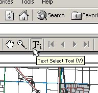
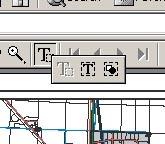
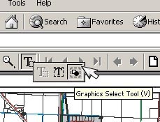
Printing Maps Using Adobe Acrobat

The map image sizes for most of the PDF Maps downloaded from skagitcounty.net are too large for most conventional printers, but that doesn't mean you can't print or save details or information off of the files you download.
To print or save an area of a map with Adobe Acrobat Reader:

1.Open the PDF map file with Adobe Reader

2. Click and hold down on the "Text Select Tool" icon on the Adobe Reader task bar:

acro1.jpg (22160 bytes)

3. A toolbar with three other options opens up:

acro3.jpg (17414 bytes)

4. Move your cursor to the small icon with the square and cicle pictured. This is the "Graphics Select Tool": Let up on the mouse button.

acro2.jpg (22309 bytes)

5. You can now use your cursor to select an area of the map image to save or print.